Photos & Drawings
In ArcheoBase, photos and drawings are archaeological data. Every image has its own structured record, linked to the units, structures, and finds it documents, so the right photo is always one click away, and no picture ever loses its context.
Book a DemoEvery image is a record
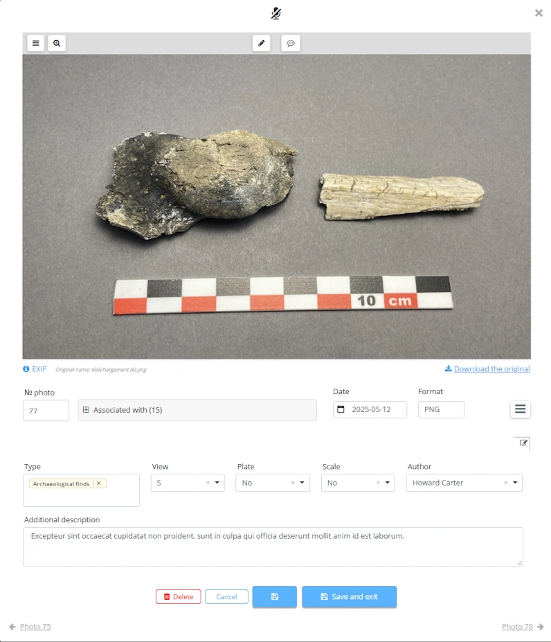

A form behind every photo.
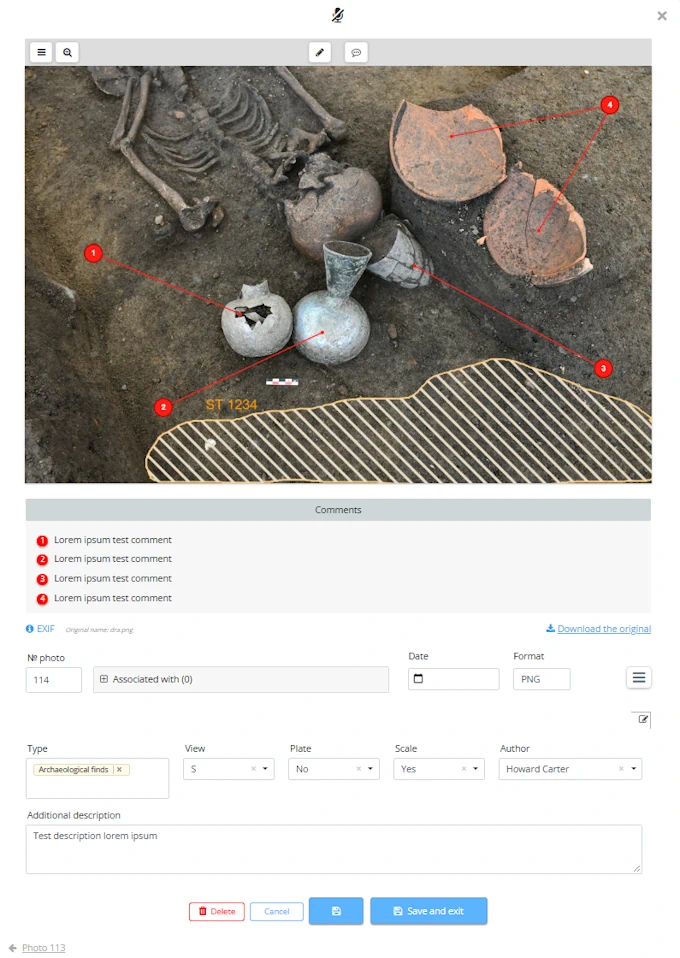
Date, type, author, associated units: each photo carries its own configurable metadata record and links to any other entity in the excavation.

One click from any form.
Open any stratigraphic unit, structure, or find and its photos are right there, no folder browsing.
Relationships work for you.
Link a photo to one unit and it appears wherever that unit appears: direct links entered once, indirect ones inferred automatically.

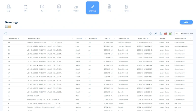
Gallery or table.
Browse photos as a mosaic or a sortable table, and filter by any form field or linked element.
Import at field pace

Batch upload, configured once.
Drop the whole day's photos in one go; association, numbering, and board recognition are set once and apply to the entire batch.

Numbering, your way.
Photo identification numbers are generated automatically or taken from the filenames your camera already wrote. Need a custom scheme? Our team can add it.

Reserve numbers before the shot.
Create a photo's form first (fields filled, number reserved) and attach the image later, when it comes off another camera. Documentation never waits for the upload.

Capture in the field.
No camera, no cables, no transfers. With ArcheoBase on your tablet, snap photos straight from the excavation and attach them to the right record on the spot. Every shot is instantly linked to its context (feature, stratigraphic unit or find) and available to your whole team the moment it's taken.
From Photos to CAD Plans
From field photos to technical drawings, ArcheoBase accepts the file formats you actually work with. Upload standard images (.jpg, .png, .gif, .bmp), publication-ready graphics (.pdf, .ai, .eps, .ps, .psd) and archival rasters (.tif) without conversion or compromise. Better still, georeferenced files (.tif, .jgw and CAD plans in .dwg) are automatically tiled and placed directly onto your map, turning your source documents into interactive spatial layers. Whatever your discipline produces, ArcheoBase knows how to store it, show it, and put it in its place.
- .JPG.PNG.GIF.BMP
- .PDF.AI.EPS.PS.PSD
- .TIF.JGW.DWG
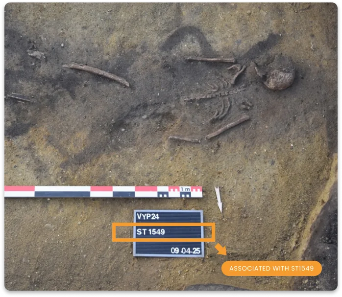
The AI reads your ID boards
During import, ArcheoBase reads the identifiers visible in your photos (the “SU 1005” or “ST 12” written on the board in the frame) and links each image to the corresponding record automatically. Hundreds of field photos sort themselves on arrival.
Annotate, comment, sketch on the photo itself

Draw directly on the image.
Brush, line, and eraser with adjustable stroke and colors: highlight the edge of a cut, circle an inclusion, sketch an interpretation. Annotations live on layers you can show or hide, so the original view is always one toggle away.

Comments that point.
Pin a comment to the exact spot it concerns; discussions stay attached to the detail they're about.

The original, untouched.
Annotations and comments never modify the source file: the original photo stays pristine in the archive.
Drawings: paper and vector, one archive
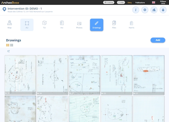
The drawing gallery works exactly like the photo gallery: every drawing has its own form and an automatically assigned number. Scanned hand drawings on graph paper upload straight into it (PNG, JPG, TIFF, PDF, AI, EPS, PSD, DWG and more), taking their place in the same numbering system as vector drawings created with the built-in 2D tool. One archive, searchable as one.
Read more
Find any image
in seconds
Search by any field (author, date, type, phase) or by linked record: every photo of one structure, every drawing of one stratigraphic unit. Filters combine, results display as gallery or table, and any selection exports.
 Search: Phase 3 structures OR SU 2014 author:Howard
Every document,
one home
Beyond photos and drawings, a Documents table centralizes everything else an intervention produces or consults: reports, sources, and every file used in an import, added automatically. Years later, whether inside ArcheoBase or in an archival export, the documentation is complete.
- .DOCX.XLSX.PPTX.TXT
- .PDF.MSG.ZIP.CSV
- .SHP.KML.MP4.MP3
- + any other file

Photos and drawings always one click away
Each media file is linked to its records: instant contextual access, no folder archaeology.

Time-saving AI
Automatic board recognition links photos to the correct forms on import, at any volume.

Built for institutional scale
No limit on photos, drawings, or documents, from a single intervention to decades of fieldwork, originals preserved.
We now have a single platform to centralize information, whether it relates to archaeological remains, structures, objects, but also photos and excavation drawings, and all of it is centralized, synchronized.
Structure your photographic documentation from the field.
Free calibration to your methodology.
Free field test. No commitment.
No lock-in. No price pressure. Built by people who listen.